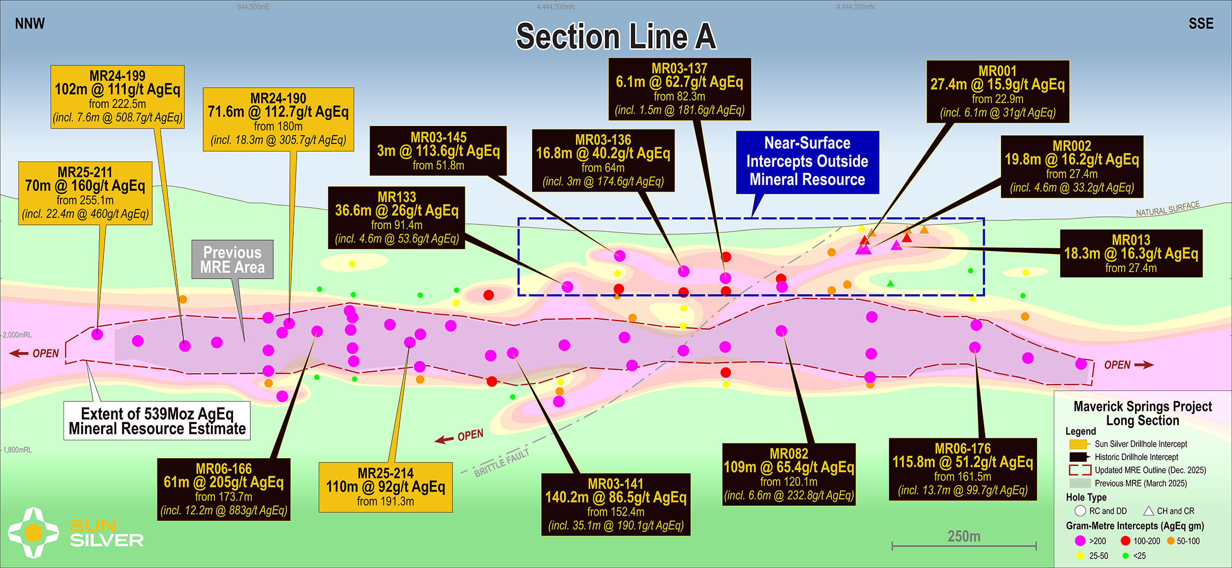
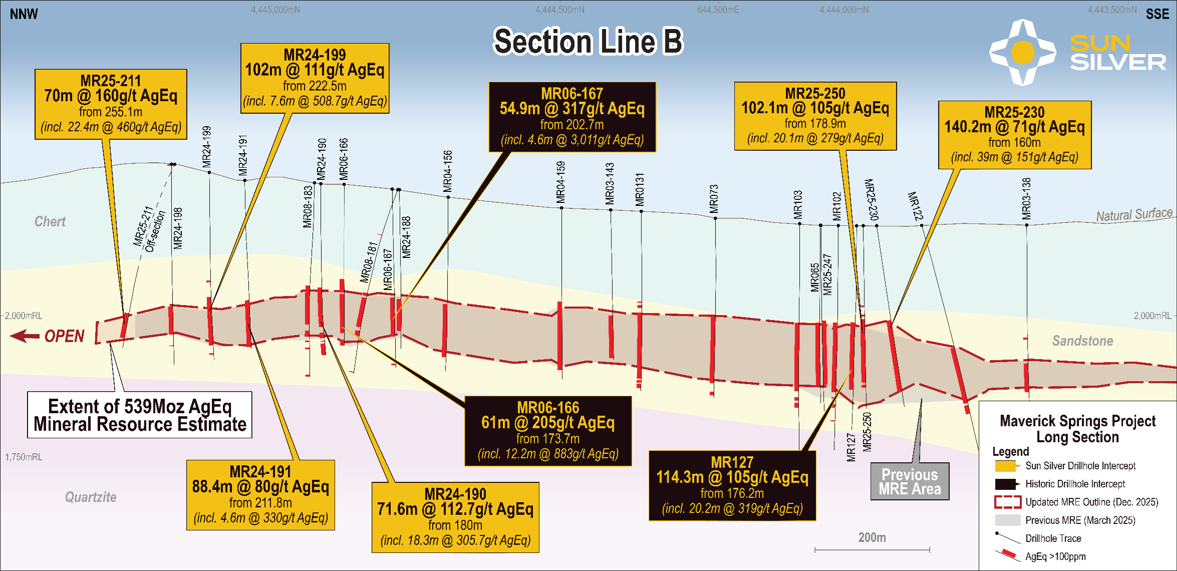
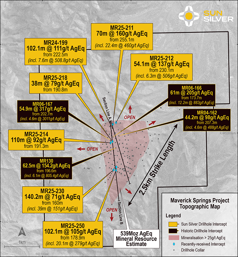
Maverick Springs

Project Location

The Maverick Springs project is located in northeast Nevada, about half-way between Elko and Ely, the northwest flank of the Maverick Springs Range on the border of Elko County and White Pine County, just off the southeast end of the Carlin Trend belt of gold-silver deposits.  Access is by a 40-kilometre gravel road from the town of Ruby Valley.

Figure 1 - Maverick Springs Project location in Nevada

Mineral Resource

Figure 2 - Inferred JORC resource estimate

The Maverick Springs Project has a JORC 2012 inferred mineral resource of 125,421,000 tonnes at an AgEQ grade of 72.4g/tonne for 292,000,000oz AgEQ.

The resource estimate has been calculated from the construction of a 3D wireframe (Figure 3) based on the drill hole database supplied which includes all drilling data from 1987 through to 2008.  The wireframe represents one large continuous body of mineralisation which lies approximately in a north-south direction with a length of 2,400 meters, a width of up to 1,200 meters, and a thickness ranging between 30 meters on the margins up to 110 meters in the centre of the deposit.

Figure 3 - Mineralised Wireframe (SGS, 2022)

Figure 4 - Conceptual Pit Model (SGS,2022)

Exploration Potential

Potential exists at the Project to expand current mineralisation and upgrade the inferred status to indicated with additional fieldwork. With majority of mineralisation below 100m depth, additional deep drilling is required to expand and upgrade the resource which would not only focus on the extensions of the mineralisation model but the development of known mineralisation specifically in the northeast portion and southern portion of the current mineralisation model.

These areas currently sit outside the whittle pit shell and have not been included in the resource estimate but may be included in the future with higher commodity prices and represent approximately one third of the mineralisation wireframe.

The images below show the block model (yellow) sitting inside the whittle pit shell (brown), and the mineralisation model (blue) which extends beyond. The north eastern & southern extension would benefit from both infill and exploratory drilling to develop.

Figure 5 - Plan View Mineralisation Model outside of Whittle Pit (ft, where Y=North)

Figure 6 - Oblique View Mineralisation Model outside of Whittle Pit (Y=North)

The current mineralisation model covers less than a quarter of the Property area and, as seen in figure 7, only has limited drilling on the peripheries of the model. Additional exploratory drilling could be used to determine if the mineralisation does extend beyond current boundaries in all directions.

A brief review of the magnetic survey from 2021 showed structures and anomalies which are likely related to the mineralisation at the Project, and a more in-depth study of this data may provide high priority exploration targets for testing. The total magnetic intensity is compared to the approximate mineralisation outline in plan view below in Figure 7.

Figure 7 - Magnetic Survey (TMI) and mineralisation extent in plan view